GeoStar WPS service address is
http://geopw.whu.edu.cn:8080/wps/GeoWebProcessingService
GRASS WPS service address is
http://geopw.whu.edu.cn:8080/wps/WebProcessingService
<?xml version="1.0" encoding="UTF-8"?>
<Execute xmlns="http://www.opengeospatial.net/wps" xmlns:ows="http://www.opengeospatial.net/ows" xmlns:xlink="http://www.w3.org/1999/xlink" xmlns:xsi="http://www.w3.org/2001/XMLSchema-instance" service="WPS" status="false" store="false" version="0.4.0">
<ows:Identifier>GeoBufferProcess</ows:Identifier>
<DataInputs>
<Input>
<ows:Identifier>InputData</ows:Identifier>
<ows:Title>Vector data to be buffered</ows:Title>
<ComplexValue schema="http://www.lmars.whu.edu.cn/ws/iodata.xsd">
<ComplexDataValue xmlns="http://www.lmars.whu.edu.cn/ws" xmlns:xlink="http://www.w3.org/1999/xlink" xmlns:gml="http://www.opengis.net/gml" xmlns:ows="http://www.opengis.net/ows">
<Reference xlink:href="http://202.114.114.71:8080/wps/samples/longrive.zip">
<ows:Format>ESRI Shapefile</ows:Format>
</Reference>
</ComplexDataValue>
</ComplexValue>
</Input>
<Input>
<ows:Identifier>Width</ows:Identifier>
<ows:Title>Buffer Distance</ows:Title>
<LiteralValue dataType="xs:double">150000</LiteralValue>
</Input>
</DataInputs>
<OutputDefinitions>
<Output>
<ows:Identifier>OutputData</ows:Identifier>
</Output>
</OutputDefinitions>
</Execute>
<?xml version="1.0" encoding="UTF-8"?>
<Execute xmlns="http://www.opengeospatial.net/wps" xmlns:ows="http://www.opengeospatial.net/ows" xmlns:xlink="http://www.w3.org/1999/xlink" xmlns:xsi="http://www.w3.org/2001/XMLSchema-instance" service="WPS" status="false" store="false" version="0.4.0">
<ows:Identifier>GeoOverlayProcess</ows:Identifier>
<DataInputs>
<Input>
<ows:Identifier>FirstInputData</ows:Identifier>
<ows:Title>FirstInputData</ows:Title>
<ComplexValue schema="http://www.lmars.whu.edu.cn/ws/iodata.xsd">
<ComplexDataValue xmlns="http://www.lmars.whu.edu.cn/ws" xmlns:xlink="http://www.w3.org/1999/xlink" xmlns:gml="http://www.opengis.net/gml" xmlns:ows="http://www.opengis.net/ows">
<Reference xlink:href="http://202.114.114.71:8080/wps/samples/longrivebuffer.zip">
<ows:Format>ESRI Shapefile</ows:Format>
</Reference>
</ComplexDataValue>
</ComplexValue>
</Input>
<Input>
<ows:Identifier>SecondInputData</ows:Identifier>
<ows:Title>SecondInputData</ows:Title>
<ComplexValue schema="http://www.lmars.whu.edu.cn/ws/iodata.xsd">
<ComplexDataValue xmlns="http://www.lmars.whu.edu.cn/ws" xmlns:xlink="http://www.w3.org/1999/xlink" xmlns:gml="http://www.opengis.net/gml" xmlns:ows="http://www.opengis.net/ows">
<Reference xlink:href="http://202.114.114.71:8080/wps/samples/sanxia.zip">
<ows:Format>ESRI Shapefile</ows:Format>
</Reference>
</ComplexDataValue>
</ComplexValue>
</Input>
<Input>
<ows:Identifier>Operator</ows:Identifier>
<ows:Title>Overlay Operator</ows:Title>
<LiteralValue dataType="xs:string">and</LiteralValue>
</Input>
</DataInputs>
<OutputDefinitions>
<Output>
<ows:Identifier>OutputData</ows:Identifier>
</Output>
</OutputDefinitions>
</Execute>
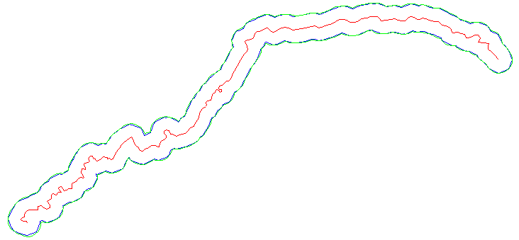
There is some difference in the analysis results between GeoStar WPS and GRASS WPS.
The result of GeoStar WPS is shown in green color, and the result of GRASS WPS is shown in blue color (Figure 1):
Figure 1
The input data is shown in Figure 2:

Figure 2
The result of GeoStar WPS is shown in Figure 3:
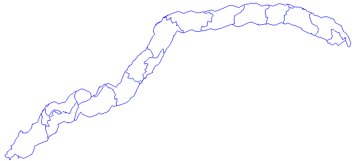
Figure 3
The result of GRASS WPS is shown in Figure 4:
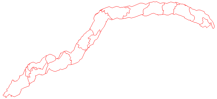
Figure 4